


CATBALOGANWATERDISTRICT
Pier II, Allen Avenue Ext.,
Catbalogan, Western Samar, Phillipines 6700
committed to be a customer service-oriented utility


CATBALOGANWATERDISTRICT
Pier II, Allen Avenue Ext.,
Catbalogan, Western Samar, Phillipines 6700
committed to be a customer service-oriented utility


Pier II, Allen Avenue extension, Catbalogan, Western Samar, Philippines.
Telephone Numbers: (055) 251-2669 ; (055) 543-9259
Catbalogan WD uses GIS in continuing swift services
To continue the swift and good services offered to its clientele the agency determined to use the Geographic Information System (GIS) technology which allows users to create interactive queries (user-created searches) analyze spatial information, edit data in maps and present the results of all these operations.
The GIS provides rapid information to users such as locations of pipelines, hydrants, water sources and alike. It also served as a marketing tool to indentify which areas of the locality needs water connections. Simply, by a single click the satellite images and photos of the consumer's locations can be identified.
by: Darwin D.
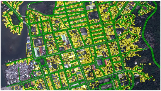
The most common method of data creation of this technology is digitization, where hard copy map or survey plan is transferred into a digital medium. Digitizing involves the tracing of geographic data directly on top of the aerial imagery instead of by the traditional method of tracing of geographic data.
The said system is currently supervised by the Senior Management Information / System Analyst, Exequiel C. Cabrigas, III, assisted by the surveyor, Cesar Jacob and Dennis M. Ala, the plotter and operator.
Such innovation is another advancement of Catbalogan WD as part of its vision to be an excellent water utility.
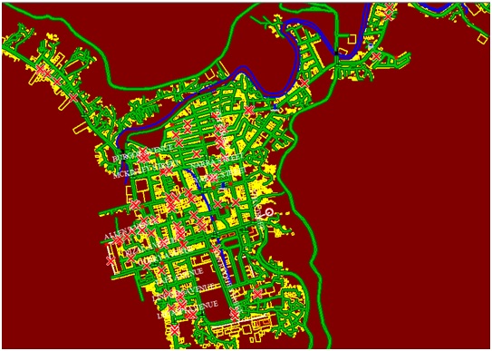
Legend:
Green Lines - Streets, Roads, Pathways
Yellow Box - Houses with/ without WSC
Blue Rectangle - Inline Booster Pump
Blue Lines - Rivers
Red x - Leakage
White Lines - Pipelines
Orange Rectangle - Courts
Dotted Red - Hydrants
Black lines - Bridges
Green Oval - Pressure Gauge
Dotted Blue - Pumping Stations